
The London Borough of Hounslow faces the challenge of finding land for many new homes over the next plan period. The mayor’s new London Plan sets Hounslow a ten-year target for 17,820 homes, with 2,800 of these for delivery on small sites of less than 0.25 hectares.
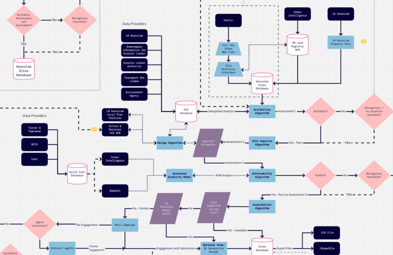
In October 2020, the London Borough of Hounslow awarded Urban Intelligence a contract to undertake an innovative approach to the traditional local plan ‘Call for Sites’. The usual process involves landowners and developers submitting and emailing PDFs of sites they are interested in for inclusion within the local plan process. Planning officers then spend months undertaking a sustainability assessment of these sites to assess their achievability, suitability, capacity, viability and availability.
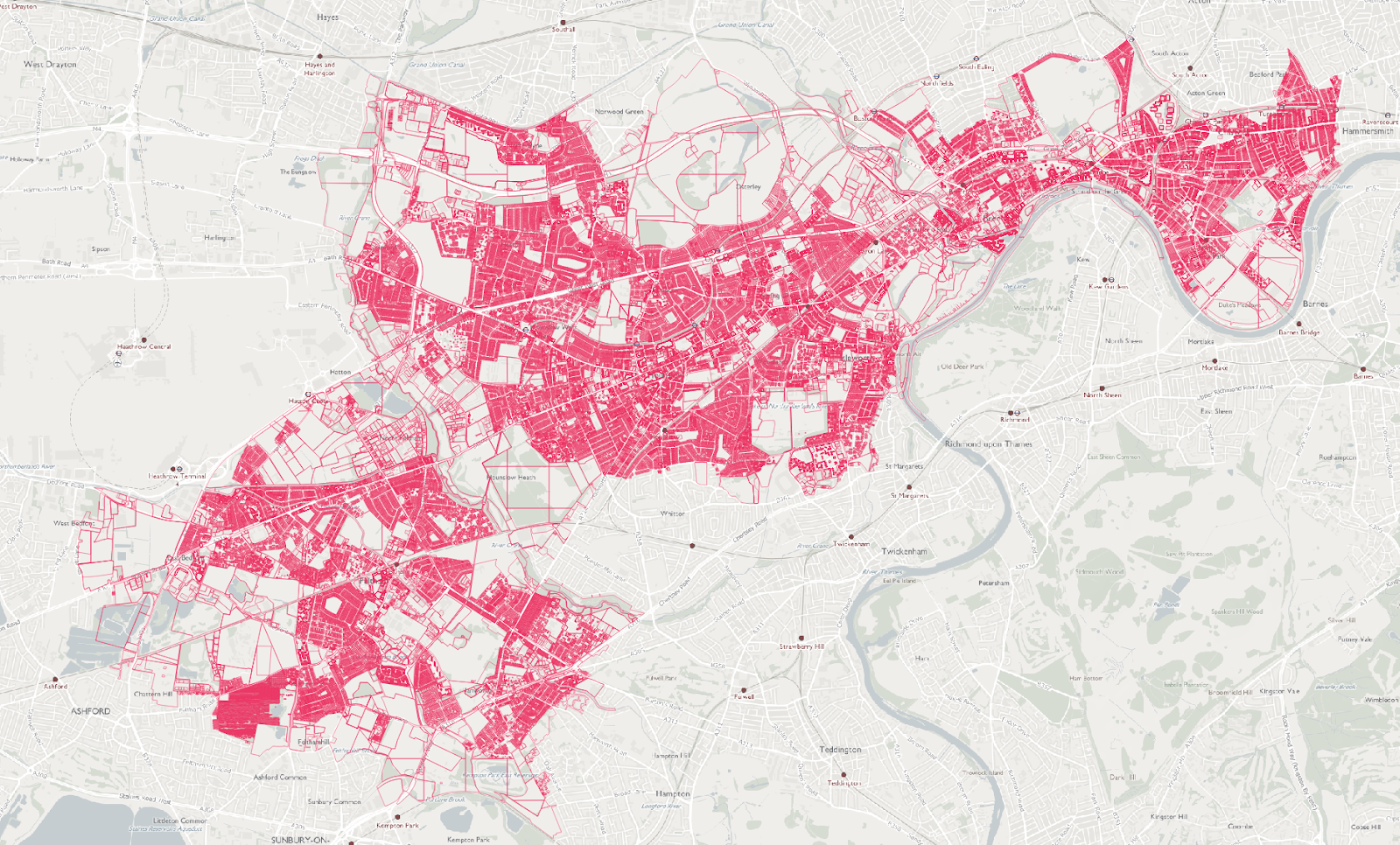
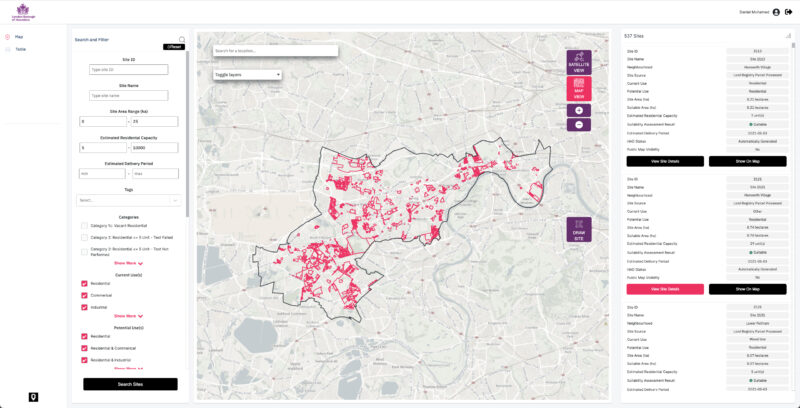
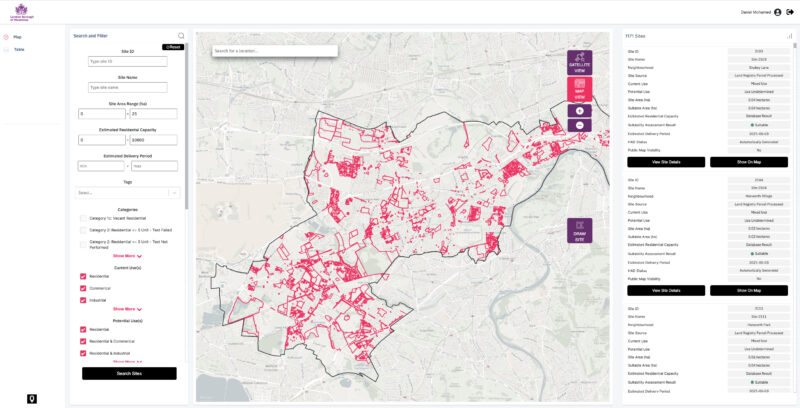
The conventional approach would typically lead to around 300-600 sites submissions to a local authority. However, with our innovative approach, we have instead analysed every single potential site across the borough. In Hounslow’s case, that’s around 115,000 (or 191x as many plots of land). Taking this fresh approach has enabled Hounslow to consider the maximum number of development sites possible for planning purposes. It will also support the borough in meeting obligations set out by the National Planning Policy Framework (NPPF) and London Plan policies.
UI has also integrated and streamlined the ‘call for sites’ exercise itself in a module within the tool built for Hounslow. The exercise now focuses on the site’s availability and the likelihood of it being brought forward for development as the site’s capacity and suitability can be assessed geospatially. Removing unnecessary questions makes it less cumbersome and faster for developers to respond to the consultation, further helping to increase the number of sites submitted. In addition, proposed sites will be automatically scored and ranked using UI’s SiteScore® algorithms with rules defined and agreed upon between UI and Hounslow planners, aided by the character and context study being undertaken in parallel by leading designers Allies & Morrison.
Hounslow now has this information presented in a state of the art software system designed with officers, especially for this particular purpose. Read on below for further details on the benefits of this project case study.
Running the numbers...
- 0Homes to be delivered in Hounslow
- 0Small sites to identify
- 0Square kilometres analysed
- 0Sites considered
“The new Sites Database will provide invaluable support to planning officers when making decisions about the development potential of identified sites. ”
Unlocking hidden value.
Meeting Hounslow’s housing needs required some creative thinking – outside the box. The Council wanted to undertake a thorough and complete sites analysis exercise, leaving ‘no stone unturned’. Working with officers, Urban Intelligence has considered every square inch of the borough.
Utilising Land Registry information, the Council’s assets, policy data and more, we’ve helped officers to build a full picture of the Borough’s development potential. Traditionally, the focus of a site identification exercise would focus on the ‘low hanging fruit’ or more prominent sites that could deliver higher unit numbers. Instead, UI’s comprehensive approach has also considered thousands of smaller sites, helping to meet the objectives of the Mayor’s new London Plan.
Furthermore, by undertaking a highly innovative rules-based and objective system to appraisal, UI has provided council leaders with a clear roadmap that officers can begin acting on immediately to meet the Council’s ambitious goals for recovery following the COVID pandemic.
Work on one digital system for sites.
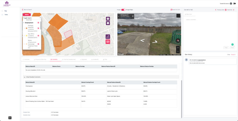
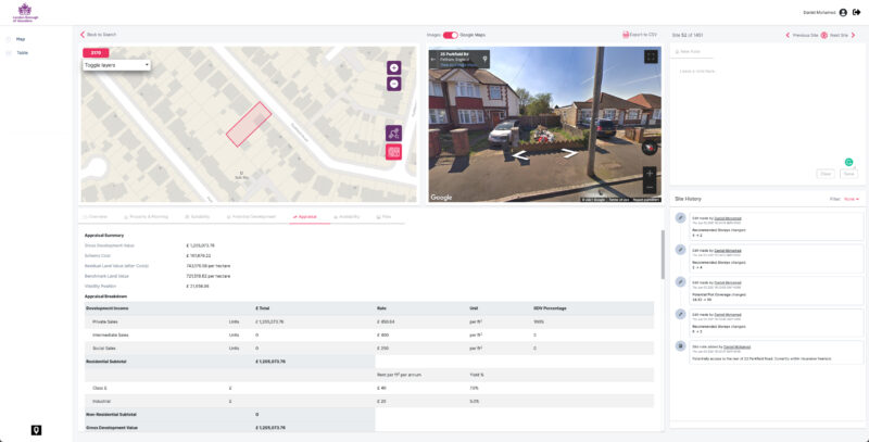
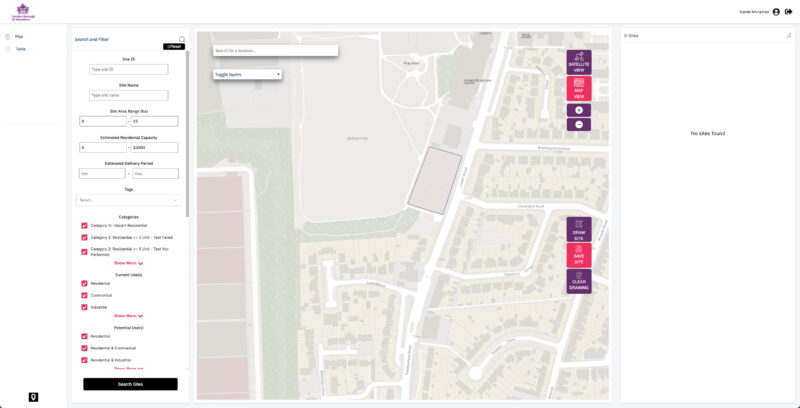
It requires a considerable amount of data gathering for each site to appraise it fully. Using the local authority’s data combined with licensed data from trusted sources such as HM Land Registry and Ordnance Survey, we’ve made it easy to see and understand everything there is to know about a site in one place. This information includes site data, GIS layers, images, and other files.
Hounslow’s site sourcing and assessments were frozen in time due to the length of time required to locate, plot and assess each respective site individually manually. So, we’ve built a dynamic ‘workstation’, where sites can be added, edited and tracked from initial identification through to potential allocation, permission and completion in real-time.
Another challenge Hounslow faced was the ability to view a site and understand its history. Officers have built a wealth of knowledge about sites, but this can get lost over time. By creating a timeline tool, officers can now find out more about previous interactions with a site and its stakeholders. There is also a clear audit trail of decisions leading to a more robust evidence base for the next local plan.
Work on one digital system for sites.
It requires a considerable amount of data gathering for each site to appraise it fully. Using the local authority’s data combined with licensed data from trusted sources such as HM Land Registry and Ordnance Survey, we’ve made it easy to see and understand everything there is to know about a site in one place. This information includes site data, GIS layers, images, and other files.
Hounslow’s site sourcing and assessments were frozen in time due to the length of time required to locate, plot and assess each respective site individually manually. So, we’ve built a dynamic ‘workstation’, where sites can be added, edited and tracked from initial identification through to potential allocation, permission and completion in real-time.
Another challenge Hounslow faced was the ability to view a site and understand its history. Officers have built a wealth of knowledge about sites, but this can get lost over time. By creating a timeline tool, officers can now find out more about previous interactions with a site and its stakeholders. There is also a clear audit trail of decisions leading to a more robust evidence base for the next local plan.
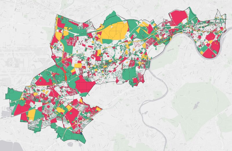
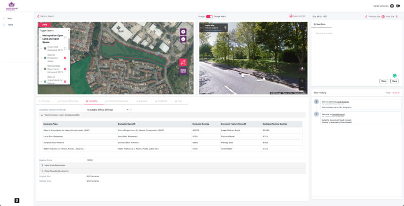
Test the impact of decision making.
Working with Hounslow planning officers, we developed a sophisticated rules-based system for analysing sites across the Borough for their development potential. This meant that sites could be evaluated rapidly with different sets of assumptions making it possible to explore different scenarios. Instead of using ‘typologies’ and crude assumptions for borough-wide policy-making, each site was assessed for its own unique development merits.
Training methods to undertake basic scoring and weighting of sites saves officers hundreds of hours, which means their valuable specialist skills can be invested in other more meaningful tasks. This process means that long lists of sites can be processed swiftly so that officers can efficiently focus on unlocking the most qualified schemes. The algorithms also improve over time as officers iterate methods to get better results. The intelligent systems can also help to identify opportunities for assembly of nearby and plots and parcels that might otherwise be missed by the naked eye alone.
The results can be tagged, scored and ranked based on the different policy objectives of different teams within the Council. Each site can be tagged and shared easily with colleagues, and data can be exported into other systems for further analysis and presentation.

Better engagement, less admin.
Hounslow wanted to be more proactive when engaging with the public and site stakeholders. The Call for Sites process is usually a frustrating activity for all parties involved. Landowners are required to invest days of time and effort collating data about their site, and then officers have to spend days processing it.
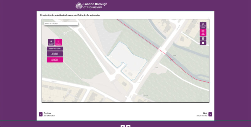
With the new smart Call for Sites form, stakeholders will only need to submit relevant information about their site. UI’s analysis of the site will mean that many of the site’s attributes are pre-processed from existing data and information held by the Council making it cheaper and easier for submission. The drawing interface enables stakeholders to build their sites directly on the map. This is then processed and analysed automatically, saving officers hours of data entry and appraisal.
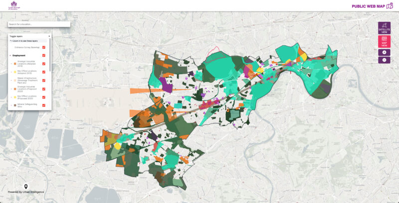
The real-time database also means that new sites can be submitted at any time and not just during fixed consultation periods. This ensures officers are armed with the latest intelligence about development opportunities within the community to promote growth in the best locations across the borough. The public can view sites on a live map alongside other key information such as planning policies.
Better engagement, less admin.
Hounslow wanted to be more proactive when engaging with the public and site stakeholders. The Call for Sites process is usually a frustrating activity for all parties involved. Landowners are required to invest days of time and effort collating data about their site, and then officers have to spend days processing it.
With the new smart Call for Sites form, stakeholders will only need to submit relevant information about their site. UI’s analysis of the site will mean that many of the site’s attributes are pre-processed from existing data and information held by the Council making it cheaper and easier for submission. The drawing interface enables stakeholders to build their sites directly on the map. This is then processed and analysed automatically, saving officers hours of data entry and appraisal.
The real-time database also means that new sites can be submitted at any time and not just during fixed consultation periods. This ensures officers are armed with the latest intelligence about development opportunities within the community to promote growth in the best locations across the borough. The public can view sites on a live map alongside other key information such as planning policies.
Project outcomes:
- Highlighted hundreds of new development opportunities
- A single view of sites across the organisation to improve working
- Live database – new sites can be added and appraised in real-time
- Pioneered new techniques that will save months of time and effort
- Lots of time-saving features to make life easier for officers and stakeholders